
GIS Data Catalog
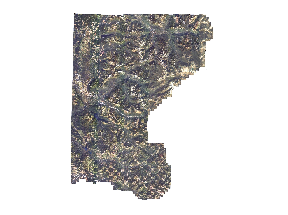
2000 Ikonos Natural Color Satellite Imagery
Learn more by reading the GIS FAQ 🗺
Summary
The dataset comprises 30 tiles (files) in IMG format that can be displayed as a seamless mosaic that covers the entire area of interest.
The dataset serves primarily as an relatively up-to-date (at time of publication) digital backdrop for GIS and cartographic display.
The absolute and horizontal accuracy should be carefully considered when either determining coordinate positions or when applying the data relative to other spatial datasets.
The data serves as a compliment to the Emerge dataset and DAIS dataset which cover the 'western' portion of the county and Vashon Island area, respectively.
These three datasets provide medium to high resolution imagery for the entire county current to late 2000.
Description
Medium resolution (i.e., 4 meter GSD (ground surface distance)) 3-band natural color satellite imagery collected from August through October 2000.
Area of interest is the eastern 'half' of King County, WA.
The data is a composite of the blue, green and red bands of the original dataset.
The area of coverage is approximately 1253 sq.
miles.
The imagery has less than 10% cloud cover.
The data exhibits some tonal and contrast variation due to spectral and illumination differences as result of the protracted acquisition campaign.
Layer information
| Layer Name | IMAGE_Ortho2000IkonosNAT |
| Subject Category | Imagery |
| Title | 2000 Ikonos Natural Color Satellite Imagery |
| Feature Count | 1 |
| Feature Type | Raster |
| Next Update | None planned |
| Spatial reference | None |
| Control ID | None |
| Place Keywords | Pacific NW, Washington, King County, Pacific Northwest |
| Theme Keywords | Ikonos2, Caterra, Space Imaging, Natural Color, Ikonos, Color, Satellite Imagery, Imagerybasemapsearthcover |
| Supplemental Information |
The images were created combining only the three visible spectrum bands of the original dataset. Users requiring the full band depth imagery are referred to the metadata for the multispectral version of the data, ms11XX.img. The original TIFF file format was not compatible with ArcView without the Image Analyst extension, therefore the data was converted to IMG format which is supported by ArcView with the standard Imagine Viewing extension. The imagery can be viewed as individual images per tile, or as a psuedo-mosaic by using the associated image catalog dbase file, ikonos_natimg.dbf. Each tile is approximately 57 sq. miles in size, with a file size of 66 mb with rrd support file. The overall dataset size is approximately 1.9 gb. The tiling scheme through which the data is provided is a regular grid imposed on an irregular overal image extent. Therefore in the border tiles the image extent is less, sometimes considerably so, than the tile polygon extent. |
Attribute information
|
OBJECTID
From Esri |
Description
Internal feature number. DomainSequential unique whole numbers that are automatically generated. |
|
Shape
From Esri |
Description
Feature geometry. DomainCoordinates defining the features. |
|
Shape_Length
From Esri |
Description
Length of feature in internal units. DomainPositive real numbers that are automatically generated. |
|
Shape_Area
From Esri |
Description
Area of feature in internal units squared. DomainPositive real numbers that are automatically generated. |
|
MosaicID
No Source Noted |
Description
Not Found DomainNot Found |
Contact information
| Maintained by | KCGIS Center |
| Primary |
KCGIS Center
giscenter@kingcounty.gov |
Terms of Use
| License | Terms of use and copyright |
Summary
The dataset comprises 30 tiles (files) in IMG format that can be displayed as a seamless mosaic that covers the entire area of interest.
The dataset serves primarily as an relatively up-to-date (at time of publication) digital backdrop for GIS and cartographic display.
The absolute and horizontal accuracy should be carefully considered when either determining coordinate positions or when applying the data relative to other spatial datasets.
The data serves as a compliment to the Emerge dataset and DAIS dataset which cover the 'western' portion of the county and Vashon Island area, respectively.
These three datasets provide medium to high resolution imagery for the entire county current to late 2000.
Description
Medium resolution (i.e., 4 meter GSD (ground surface distance)) 3-band natural color satellite imagery collected from August through October 2000.
Area of interest is the eastern 'half' of King County, WA.
The data is a composite of the blue, green and red bands of the original dataset.
The area of coverage is approximately 1253 sq.
miles.
The imagery has less than 10% cloud cover.
The data exhibits some tonal and contrast variation due to spectral and illumination differences as result of the protracted acquisition campaign.
Contact information
| Maintained by | KCGIS Center |
| Primary |
KCGIS Center
giscenter@kingcounty.gov |
Terms of use and copyright
| License | Terms of use and copyright |
Change history
| 5/1/2001 |
The resulting natural color image tiles still exhibited tonal variation as most tiles incorporated a portion of more than one of the original satellite swath panels. ArcView Image Analyst was employed to adjust the brightness and contrast of individual tiles to produce a final natural color image product that accomodated this variation as much as possible. |
| 3/15/2001 |
The images were received in UTM Zone 10 NAD 83 projection. King County's standard projection is WA State Plane North, HPGN Datum. The grids from the previous step were processed to convert (remove) the zero values within the grid. This was done to remove the areas of zero values around the edges of each panel which would mask areas of adjacent panels during a merge operation. All the edited panels of each respective band were merged in ArcInfo and then the merged grid was reprojected to the King County standard. |
| 3/15/2001 |
The images were received from the vendor on CD-ROM as 4 separate chromatic files/image panel in 11 bit TIFF format. Files were named by product order number, source image number and tile position, e.g. po_PPPPP_bnd_SSSXXYY.tif where PPPPP is the order number, bnd is the three letter band abbreviation (red,blu,grn,nir), SSS is the source image number, and XXYY is the x,y tile position of the image (i.e., po_60094_red_0000001.tif). The images exhibited strong tonal and spectral variation between the satellite swath panels. To accomodate for this, the images were read into ERDAS where a histogram matching routine was applied. The rebalanced images were then converted to ArcInfo grids to allow for reprojection. |
| 3/15/2001 |
To provide the data as a seamless mosaic in equal-sized tiles, a new tile scheme was created in ArcInfo using the generate command with the fishnet option. The merged grids of each band were clipped to the polygons of the tiling scheme using the gridclip command in ArcInfo. A 250 foot buffer was applied during the clipping command so that any tile has marginal overlap with its neighbor. The clipping process resulted in three separate files (one for each band for each tile). For each tile the three bands were stacked and converted to Imagine format in ArcInfo. |