
GIS Data Catalog
Agricultural Land Use 2013
Learn how to get an ArcGIS Online account 🗺
Use this Data
|
Links
How to use in ArcGIS Pro |
|
| Sharing Status | Not Public |
Summary
To assess agricultural activity and land use in King County.
Description
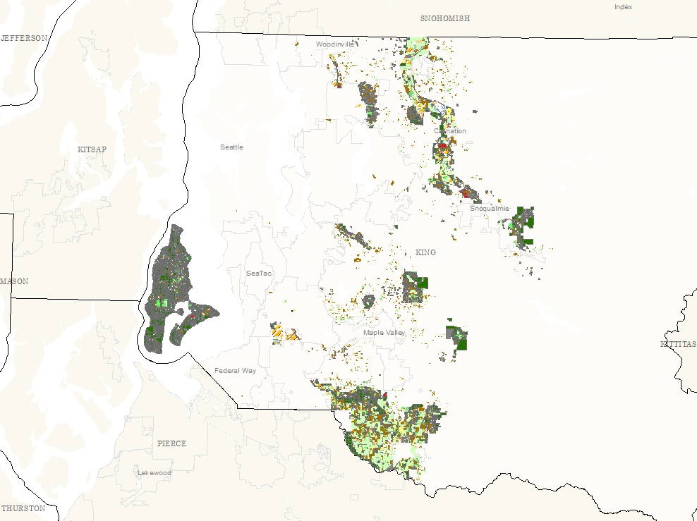
Agricultural Land Uses identified through aerial photography and confirmed in some areas with field verification.
Complete coverage within the Agricultural Production Districts and on Vashon-Maury Island; partial coverage in rural areas.
Notes: 1.
Depending upon the use of rotation and presence of activity, some parcels categorized as Managed or Unmanaged Grassland could be categorized as Livestock/Forage.
Attempts were made to determine if any grassland fields were previously used or looked as if they were being kept up for future use (i.e. well-managed fencing, electrical tape).
2.
When a parcel had multiple land types it was divided into multiple records to indicate these uses.
This was not done for buildings on an agriculturally-used parcel (such as a house on a livestock property) or when the other land type was insignificant (such as some trees on a property).
Layer information
| Layer Name | ag_landuse2013_area |
| Subject Category | Natural Resources |
| Title | Agricultural Land Use 2013 |
| Feature Count | 25445 |
| Feature Type | Polygon |
| Next Update | None planned |
| Spatial reference | EPSG:2926 |
| Control ID | 2488 |
| Place Keywords | Pacific NW, King County, WA, Washington State |
| Theme Keywords | Agriculture, Natural Resources, Farming, Land Use, Environmental, Natres, Farming, Environment |
| Supplemental Information | None |
Attribute information
|
OBJECTID
From Esri |
Description
Internal feature number. DomainSequential unique whole numbers that are automatically generated. |
|
PIN
From King County |
Description
10 digit Parcel Identification Number DomainNot Found |
|
APD
From King County |
Description
Agricultural Production District DomainEnumclaw Plateau, Lower Green, Sammamish, Snoqualmie, Upper Green |
|
LUcode2013
From King County |
Description
Unique values to identify land uses, created for ease of coding. Domain1 - Livestock, Forage 10 - Too Wet to Farm 11 - Topsoil Production 12 - Marsh or Wetland 13 - Other (roads, residential, water bodies, buffers, etc.) 1a - Managed Field, Grassland 1b - Corn (Field) 20 - Horse 3 - Market Crops (Produce) 4 - Unmanaged Grassland 5 - Nursery 6 - Tree Farm 6a - Orchard 6b - Unmanaged Orchard 6c - Grapes 7 - Sod Farm 8 - Forested 9 - Developed Recreation |
|
LUdesc2013
From King County |
Description
Land Use Description DomainCorn (Field) - Stand alone corn field use for grain or silage (vegetable corn included in Market Crops/Produce). Recorded as Livestock/Forage in 2009 survey. Forested - Presence of forest, typically continuous multi-parcel tracts of trees; small, isolated groves not included Grapes - Presence of grapes Horse - Horses present Livestock, Forage - Livestock present on the field, visible animal waste, presence of hay bales, visible tire tracks from cutting, baling or chopping, manure spreading Managed Field, Grassland - Grassland or field where there are no signs of livestock/forage but is being cut at agronomic stubble heights (<3 inches) Market Crops (Produce) - Flower and vegetable gardens (must be larger than only self-sustaining) Marsh or Wetland - Marsh or Wetland either containing or adjacent to a Sensitive Areas Ordinance Wetland Nursery - Presence of a nursery Orchard - Presence of at least 8 orchard trees Other (roads, residential, water bodies, buffers, etc.) - Roads, rivers and lakes, buildings, any lawn or grass cut too short to be used for grazing, houses, mining or construction, non-tillable surfaces, non-agriculture parcels that are not covered by other categories Sod Farm - Presence of sod farm Developed Recreation - Presence of ball fields (baseball, soccer, etc.), parks, golf courses, grassland preserves that can be used for recreational hiking, sports complexes, campgrounds Too Wet to Farm - Not currently being farmed, and presence of standing water visible from road or in aerial photos in both wet and dry seasons, or year-round open water. Topsoil Production - Topsoil Production Tree Farm - Presence of a tree farm (e.g. poplar plantation) Unmanaged Grassland - Grassland or field where there are no signs of livestock/forage that is not being cut for length Unmanaged Orchard - Presence of orchard trees that show no signs of being harvested, pruned, fruit falling to the ground; collection must be visible on aerial photos |
|
Notes
From King County |
Description
Not Found DomainNot Found |
|
GIS_Acres
From King County |
Description
Acres calculated from GIS Domain5.6e-07 to 525.8909622 by |
|
Shape
From King County |
Description
Feature geometry. DomainCoordinates defining the features. |
|
Shape.STArea()
From SQL Server |
Description
Returns the area of a geometry instance in square units, based on the spatial reference identifier (SRID) of the geometry. DomainDouble |
|
Shape.STLength()
From SQL Server |
Description
Returns the total length of the elements in a geometry instance. DomainDouble |
Contact information
| Maintained by | DNRP - Water and Land Resources |
| Primary |
Harkeerat Kang
Harkeerat.Kang@kingcounty.gov |
Terms of Use
| License | Terms of use and copyright |
Use this Data
|
Links
How to use in ArcGIS Pro |
|
| Sharing Status | Not Public |
Summary
To assess agricultural activity and land use in King County.
Description
Agricultural Land Uses identified through aerial photography and confirmed in some areas with field verification.
Complete coverage within the Agricultural Production Districts and on Vashon-Maury Island; partial coverage in rural areas.
Notes: 1.
Depending upon the use of rotation and presence of activity, some parcels categorized as Managed or Unmanaged Grassland could be categorized as Livestock/Forage.
Attempts were made to determine if any grassland fields were previously used or looked as if they were being kept up for future use (i.e. well-managed fencing, electrical tape).
2.
When a parcel had multiple land types it was divided into multiple records to indicate these uses.
This was not done for buildings on an agriculturally-used parcel (such as a house on a livestock property) or when the other land type was insignificant (such as some trees on a property).
Contact information
| Maintained by | DNRP - Water and Land Resources |
| Primary |
Harkeerat Kang
Harkeerat.Kang@kingcounty.gov |
Terms of use and copyright
| License | Terms of use and copyright |