
GIS Data Catalog
Extent of Imagery and other Raster Datasets for King County
Learn how to get an ArcGIS Online account 🗺
Use this Data
|
Links
How to use in ArcGIS Pro |
|
| Sharing Status | Not Public |
Summary
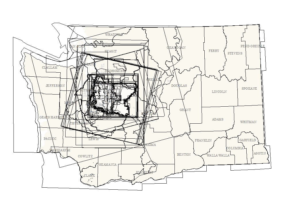
Few of the raster data sets in the SDW have coincident extents so the extents polygons can be used to determine if valid data from that dataset exists for a given area of interest.
These extent polygons are not tiling or spatial indexes as they do not indicate how the data is subdivided and stored in the warehouse.
Users are refered to the tiling indexes and associated metadata available on the KCGIS Spatial Data Catalog webpage at This theme may be used in conjunction with the raster status indexes, RASTSTAT_7500_AREA and RASTSTAT_TRMBR_AREA, which illustrate the availability of tiles in the raster library.
The status indexes will show if a tile exists for a given dataset but the extent theme is required to determine if the full extent of a given tile contains valid data, i.e, useable imagery, elevation grid, landcover data.
Description
Geographic extent of each image/raster data set in the King County Spatial Data Warehouse described as a bounding polygon.
The individual polygon bounds are stored separately as x_'dataset-name'.shp for maintenance purposes and also as a composite (merged) layer of all overlapping bounds.
The polygon bounds describe the true edge of valid data of each dataset, which may lie inside the extent of NULL or zero values, or the extent of the minimal-bounding rectangle (mbr) of the dataset.
Many of the bounding polygons names in the merged file and the names of the individual files complement names of data subdirectories within the idxp7500 and idxptrmbr master directories, as the full extent of these datasets is comprised of multiple tiles of more limited extent.
Other bounding extent titles will not have a subdirectory for the dataset as they exist solely as a single theme at the KeyRegion (maximum extent) level.
Layer information
| Layer Name | allextents_area |
| Subject Category | Survey |
| Title | Extent of Imagery and other Raster Datasets for King County |
| Feature Count | 192 |
| Feature Type | Polygon |
| Next Update | As needed |
| Spatial reference | EPSG:2926 |
| Control ID | 752 |
| Place Keywords | Pacific NW, WA, Washington State, King County |
| Theme Keywords | Maxiumum Tiling Extent, Reference Grids, Image Data, Raster Data, Survey |
| Supplemental Information |
None |
Attribute information
|
OBJECTID
From ESRI |
Description
Internal feature number. DomainSequential unique whole numbers that are automatically generated. |
|
SHAPE
From ESRI |
Description
Feature Geometry DomainCoordinates defining the features |
|
lyrfile
From King County |
Description
Production LYRFile name DomainName of lyr file proceeded by name of data group |
|
SerialID
No Source Noted |
Description
Not Found DomainNot Found |
|
ExtentFileName
No Source Noted |
Description
Not Found DomainNot Found |
|
SourceDate
No Source Noted |
Description
Not Found DomainNot Found |
|
mosaicid
From King County |
Description
Unique mosaic identifier for application coding Domain100101.00000000 to 100326.00000000 by |
|
DataClass
No Source Noted |
Description
Not Found DomainNot Found |
|
GDBName
No Source Noted |
Description
Not Found DomainNot Found |
|
DataSourcePath
No Source Noted |
Description
Not Found DomainNot Found |
|
filename
No Source Noted |
Description
Not Found DomainNot Found |
|
DataFormat
No Source Noted |
Description
Not Found DomainNot Found |
|
Origin
No Source Noted |
Description
Not Found DomainNot Found |
|
Title
No Source Noted |
Description
Not Found DomainNot Found |
|
Abstract
No Source Noted |
Description
Not Found DomainNot Found |
|
Purpose
No Source Noted |
Description
Not Found DomainNot Found |
|
SHAPE.STArea()
No Source Noted |
Description
Not Found DomainNot Found |
|
SHAPE.STLength()
No Source Noted |
Description
Not Found DomainNot Found |
Contact information
| Maintained by | KCGIS Center |
| Primary |
KCGIS Center
giscenter@kingcounty.gov |
Terms of Use
| License | Terms of use and copyright |
Use this Data
|
Links
How to use in ArcGIS Pro |
|
| Sharing Status | Not Public |
Summary
Few of the raster data sets in the SDW have coincident extents so the extents polygons can be used to determine if valid data from that dataset exists for a given area of interest.
These extent polygons are not tiling or spatial indexes as they do not indicate how the data is subdivided and stored in the warehouse.
Users are refered to the tiling indexes and associated metadata available on the KCGIS Spatial Data Catalog webpage at This theme may be used in conjunction with the raster status indexes, RASTSTAT_7500_AREA and RASTSTAT_TRMBR_AREA, which illustrate the availability of tiles in the raster library.
The status indexes will show if a tile exists for a given dataset but the extent theme is required to determine if the full extent of a given tile contains valid data, i.e, useable imagery, elevation grid, landcover data.
Description
Geographic extent of each image/raster data set in the King County Spatial Data Warehouse described as a bounding polygon.
The individual polygon bounds are stored separately as x_'dataset-name'.shp for maintenance purposes and also as a composite (merged) layer of all overlapping bounds.
The polygon bounds describe the true edge of valid data of each dataset, which may lie inside the extent of NULL or zero values, or the extent of the minimal-bounding rectangle (mbr) of the dataset.
Many of the bounding polygons names in the merged file and the names of the individual files complement names of data subdirectories within the idxp7500 and idxptrmbr master directories, as the full extent of these datasets is comprised of multiple tiles of more limited extent.
Other bounding extent titles will not have a subdirectory for the dataset as they exist solely as a single theme at the KeyRegion (maximum extent) level.
Contact information
| Maintained by | KCGIS Center |
| Primary |
KCGIS Center
giscenter@kingcounty.gov |
Terms of use and copyright
| License | Terms of use and copyright |
Change history
| 1/30/2015 |
Add 12 new extents, 6 for DGM and 6 for GHS, to represent the new time-series Digital Ground Model (elevation) layers and the parallel Ground Hillshade layers. Also performed general cleanup of the EXTENT_LUT (master enterprise control table) standardizing naming conventions. Cleaned up stale data by removing x_ extent files that no longer matched records in table. |
| 4/18/2014 |
Added extents for new 2011 CCAP and NLDB forest fragmentation, impervious surface, and landcover layers. Also added ArcGIS Server BaseMap services to IMAGE category to migrate access away from separate Base Map Chooser in Libtool (which will go away in Libtool 2). These will now be available either in the Quick Pick list or as a mosaic in the Image Picker. |
| 3/1/2011 |
Extent added for new 2009 Impervious Surface |
| 2/2/2011 |
Extents added for KCGISGenericBase and KCGISHybridBase to allow these ArcGIS Server basemaps to be served up via lyr files thru LibTool (Imagery mosaics) |
| 10/1/2010 |
Added extents for four Forest Fragmentation landcover themes produced by Water and Lands Division (Ken Rauscher). These were for years 1992, 1996, 2001 and 2006. |
| 8/1/2010 |
Added extents for 2010 King County ortho project. Two separate extents - one for 6 inch data and one for 1 foot data, for each of the natural color and color infrared deliverables. |
| 5/5/2010 |
Added extent for eCityGov Alliance 2009 project. Extent provided early in project was adjusted slightly to fit the actual extent of imagery provided. |
| Update 8 |
Extents added for 2006 NLCD Impervious, 2006 NLCD Landcover, 1971-2000 Avg Precipitation, 1971-2000 Avg Maximum Temperature, 1971-2000 Avg Minimum Temperature, Avg January Minimum Temperature and Avg July Maximum Temperature for both Washington State and King County. |
| Update 9 |
Added exents for two new surface classification datasets: reg_bht030 and reg_vht030. These are datasets that depict manmade feature building heights and vegetation structure heights, respectively. These were constructed from combinations of first-return lidar, bare-earth model lidar and impervious surface interpretation. |
| Update 10 |
For each new dataset a shapefile is manually created by heads-up digitizing based on the extent of valid data in the raster data set. A new control record is added to the Excel spreadsheet that contains a description of the dataset and other information about how the data is deployed through the SDW. A script called BuildExtentIndex.py found in the RasterMaint>MakeAllExtents workspace appends all individual x_'dataset name" extents files found in FDS Raster_Extents_Separates and joins the tabular data which has been loaded to a GDB table called EXTENTLUT. |