
GIS Data Catalog
Incorporated Areas (cities) in Three County Area - Boundary Line
Learn how to get an ArcGIS Online account 🗺
Use this Data
|
Links
How to use in ArcGIS Pro |
|
| Sharing Status | Not Public |
Summary
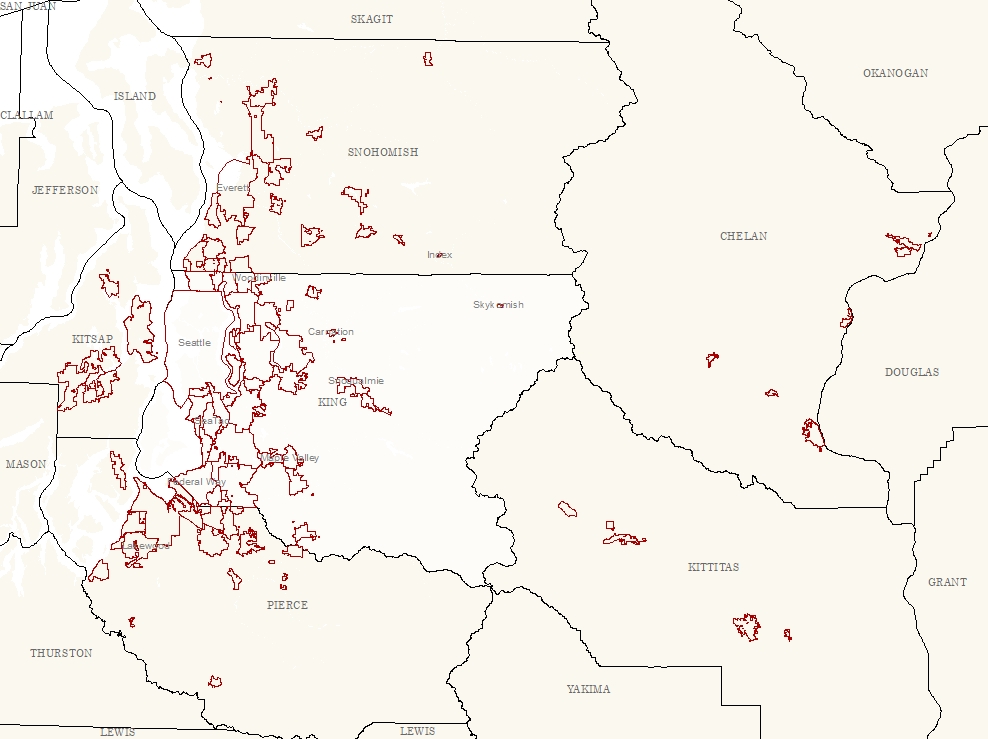
General cartographic, analysis and query of jurisdictional (city) information for the three county area as well as the bordering Chelan, Kitsap, and Kittitas counties.
Does not include data for unincorporated areas.
Even though this layer is built from and kept current to the contributing sources, users should may wish to use the separate source data layers when working in a more limited area to take advantage of any information or functionality not transferred to the composite.
CITY_3CO stores only a single user attribute: NAME.
Description
Compilation of city jurisdictional information from six counties: King, Pierce, Snohomish, Chelan, Kitsap, and Kittitas.
Uses the best available information from each of the six counties to produce the composite product.
Updated whenever changes are made to any of the source data sets.
For King County this will be whenever CITY_AREA (parent is CITY_ANNEX) is updated to Spatial Data Warehouse.
Updates are made so that the King County portion of this composite is synchronous with the information in the master King County jurisdiction layer.
Layer information
| Layer Name | city_3co_boundary_line |
| Subject Category | Administrative |
| Title | Incorporated Areas (cities) in Three County Area - Boundary Line |
| Feature Count | 483 |
| Feature Type | Line |
| Next Update | As needed |
| Spatial reference | EPSG:2926 |
| Control ID | 3024 |
| Place Keywords | Washington State, King County, WA, Pacific NW |
| Theme Keywords | Incorporated, City, Admin |
| Supplemental Information |
Source data and credit for adjoining counties: Pierce: CITY.SHP Snohomish: CITIES.SHP |
Attribute information
|
OBJECTID
From ESRI |
Description
Internal feature number. DomainSequential unique whole numbers that are automatically generated. |
|
LEFT_FID
No Source Noted |
Description
Not Found DomainNot Found |
|
RIGHT_FID
No Source Noted |
Description
Not Found DomainNot Found |
|
SHAPE
From ESRI |
Description
Feature geometry. DomainCoordinates defining the features. |
|
SHAPE.STLength()
No Source Noted |
Description
Not Found DomainNot Found |
Contact information
| Maintained by | KCGIS Center |
| Primary |
KCGIS Center
giscenter@kingcounty.gov |
Terms of Use
| License | Terms of use and copyright |
Use this Data
|
Links
How to use in ArcGIS Pro |
|
| Sharing Status | Not Public |
Summary
General cartographic, analysis and query of jurisdictional (city) information for the three county area as well as the bordering Chelan, Kitsap, and Kittitas counties.
Does not include data for unincorporated areas.
Even though this layer is built from and kept current to the contributing sources, users should may wish to use the separate source data layers when working in a more limited area to take advantage of any information or functionality not transferred to the composite.
CITY_3CO stores only a single user attribute: NAME.
Description
Compilation of city jurisdictional information from six counties: King, Pierce, Snohomish, Chelan, Kitsap, and Kittitas.
Uses the best available information from each of the six counties to produce the composite product.
Updated whenever changes are made to any of the source data sets.
For King County this will be whenever CITY_AREA (parent is CITY_ANNEX) is updated to Spatial Data Warehouse.
Updates are made so that the King County portion of this composite is synchronous with the information in the master King County jurisdiction layer.
Contact information
| Maintained by | KCGIS Center |
| Primary |
KCGIS Center
giscenter@kingcounty.gov |
Terms of use and copyright
| License | Terms of use and copyright |
Change history
| 1/1/2026 |
Addition of five contiguous, city-owned parcels (212970-0240, 212970-0245, 212970-0260, 212970-0270, and 212970-0271) adjacent to Big Rock Park for municipal purposes, as per City of Duvall Ord. No. 1341, effective January 1, 2026. |
| 9/23/2025 |
Addition of a portion of the SE 440th Street right of way to the City of Enumclaw as per KC Ord No 19973 and Addition of a portion of the 384th Ave SE right of way to the City of Snoqualmie as per KC Ord No 19974. |
| 7/1/2024 |
Addition of the NE 97th Street Annexation to the City of Redmond, as per BRB File 2418 and City of Redmond Ordinance 3165. |
| 3/27/2024 |
Previous 2022 Annexation of SE 448th St right-of-way (from the wester right-of-way of 244th Ave SE approximately 1148' westerly) to the City of Enumclaw as per file LUA 2022-0041 – Gambrel Preliminary Plat. |
| 1/1/2024 |
Annexation of the property known as The Bridges, currently located in the City of Kent, into the City of Auburn as per Auburn Ordinance No. 6928, pusuant to RCW 35.10.217(2). |
| 11/1/2023 |
City of Redmond annexation of city-owned parcel 272605-9145 via Ordinance No. 3128, pursuant to RCW 35A.14.300, Annexation For Municipal Purposes. . |
| 3/13/2023 |
Addition of Grace Point Annexation to the City of Enumclaw as per BRB 2413 and City of Enumclaw Ord No 2479. |
| 11/23/2021 |
Addition of Falkenberg Annexation to the City of Carnation as per BRB 2397 and Carnation Ord No 926. |
| 8/27/2021 |
Addition of City of Woodinville Roundabout annexation, City of North Bend 428th Ave SE and SE 136th & 436th Ave SE boundary revisions. |
| 3/6/2021 |
Addition of the Mt Rainier Christian Center Annexation area to the City of Enumclaw and the Graves Annexation area to the City of Renton. |
| 9/23/2020 |
Addition of the Warner Ave/SE 456th Street Annexation to the City of Enumclaw and the South 320th Street Annexation to the City of Federal Way. |
| 12/22/2019 |
Addition of the Bill Annexation area to the City of Renton and ROW segments to the City of Normandy Park |
| 11/10/2019 |
Addition of Rainier Ridge annexation to Maple Valley, Tim D annexation to Renton, King County Island annexation to Issaquah, and NE Rose Hill annexation to Redmond. |
| 11/10/2019 |
Addition of Highland Meadows annexation area to the City of Renton |
| 7/29/2019 |
Addition of Hill Creek annexation area to the City of Milton |
| 12/1/2016 |
Added 3 counties: Chelan; Kitsap; & Kittitas. Includes Hawk Annexation to Covington |
| 7/24/2015 |
Incorporated additons from most recent CITY_AREA |
| 3/7/2014 |
Incorporated additons from most recent CITY_AREA |
| 6/12/2013 |
Incorporated additons from most recent CITY_AREA |
| 11/2/2012 |
Updated against CITY_AREA - 20121102 vintage to include Snoqualmie Mill Annexation to Snoqualmie, and several other smaller annexations arround the county. |
| 6/7/2012 |
Updated against: CITY_AREA - 20120601 vintage to include 3 South Bellevue Annexations to Bellevue F53_CITY - 20111006 vintage (Snohomish Co.) F61_CITIES - 20111121 vintage (Pierce Co.) Updated for ArcGIS 10.0 metadata workflow |
| 6/15/2011 |
Updated against: CITY_AREA - 201106 Kirkland Annexation F53_CITY - 201001 vintage (Snohomish Co.) F61_CITIES - 201009 vintage (Pierce Co.) |
| 1/21/2010 |
Updated against: CITY_AREA - 20100113 vintage F53_CITY - 20090512 vintage F61_CITIES - 20090430 vintage Includes annexations to North Bend and Renton as well as others. Transit will now copy version of city_3co_jurisdiction directly from CITY_3CO_EDIT. |
| 5/1/2009 |
Updated against: CITY_AREA - 200905 vintage F53_CITY - 200905 vintage F61_CITIES - 200904 vintage Geoprocessing routines also revamped to improve topology quality and reduce slivers and gaps. Original routine, now upgraded, is still run. It now includes a step to use tri-county area from WASHCO to union in unincorporated areas. At end of routine manual QC and editing is done. Final wrapup script is used to create: CITY_3CO_AREA - cities only across three counties CITY_3CO_UNINC_AREA - cities and unincorporated area across three counties CITY_3CO_JURISDICTION - unpulblished versioin of CITY_3CO_UNINC_AREA that is used by DOT-Transit for internal applications. It has some renamed items and additonal items joined on the city name item. |
| 4/1/2008 |
Built first edition from new workflow. Published to SDW. Data currency valid as: King County - 200802 Snohomish County - 200712 Pierce County - 200710. |
| 4/1/2008 |
Workflow was revamped to incorporate automated data import, appending and dissolve. Though this automated method does not produce as clean a data set as the previous manual effort, the new method allows more frequent updates that can be tied directly to when any of the source data is republished. In addition, as the Pierce and Snohomish County source data do not include a unincorporated polygon this information is not longer maintained as part of the composite. The main steps of the routine are: 1. Import the source components, dropping all items except for jurisdiction name. Standardizing NAME item and standardizing case of values. 2. Append the modified components to a single target template. 3. Dissolve on NAME to remove boundaries within cities that cross county boundaries. |
| Update 27 |
Incorporated additons from most recent CITY_AREA |
| Update 28 |
Updated against: CITY_AREA - 20100329 vintage to include North Highline Annexation to Burien F53_CITY - 20090512 vintage (Snohomish Co.) F61_CITIES - 20090430 vintage (Pierce Co.) |
| Update 29 |
Updated against: CITY_AREA - 20100329 vintage to include North Highline Annexation to Burien F53_CITY - 20090512 vintage (Snohomish Co.) F61_CITIES - 20090430 vintage (Pierce Co.) |
| Update 30 |
Updated against: CITY_AREA - 20100202 vintage F53_CITY - 20090512 vintage F61_CITIES - 20090430 vintage |