
GIS Data Catalog
Parks Conservation Easements
Learn how to get an ArcGIS Online account 🗺
Use this Data
|
Links
How to use in ArcGIS Pro |
|
| Sharing Status | Not Public |
Summary
Conservation easements hold strict legal restrictions to preserve the conservation value of the land.
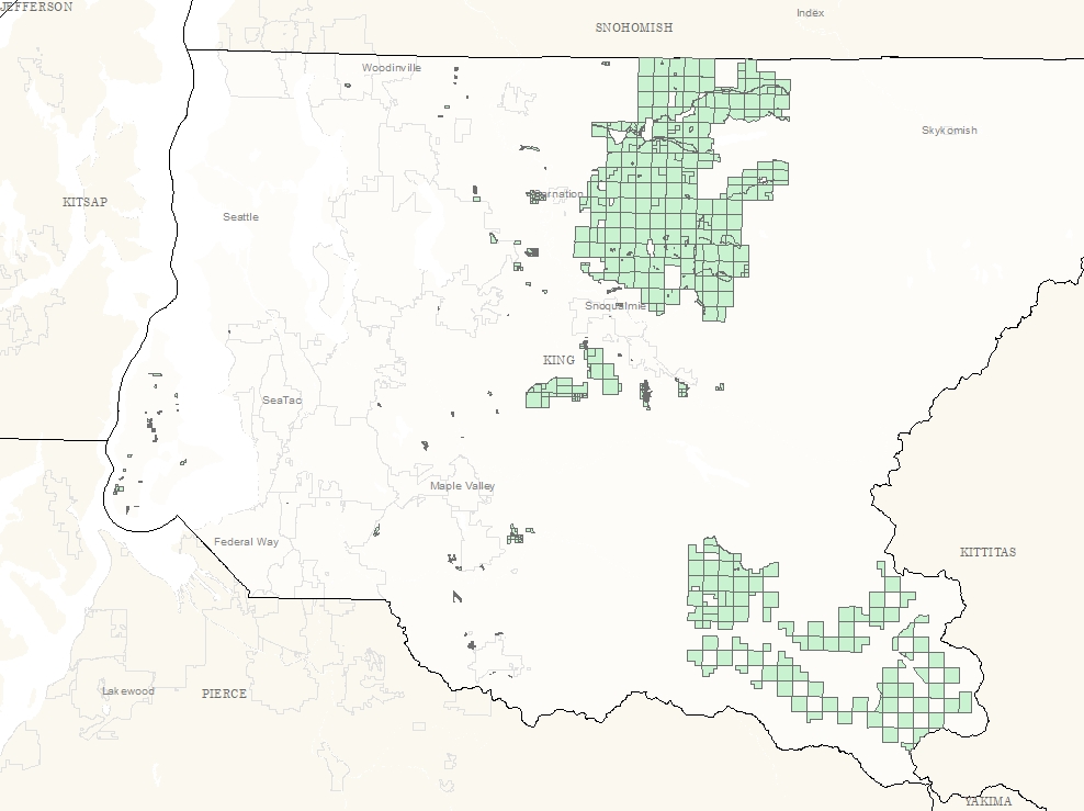
This data set identifies the footprint of all conservation easements in King County held by King County Parks and Recreation.
Any alterations of these lands must be in compliance with the conditions of the deed, these sites shall be monitored on an annual basis to verify the conditions are being upheld.
Description
This data set contains all the conservation easements King County Parks holds on land within King County, these easements hold strict legal restrictions on the property in order to protect the conservation values of the land.
The conservation area shapefile is a subset of the Park Property layer, which contains parcels and sub-parcels with a King County Parks property interest.
The conservation area shapefile is composed of King County Property interests where the interest type is an easement only, and of those easements, only conservation easements have been selected.
Layer information
| Layer Name | conservation_easement_area |
| Subject Category | Property |
| Title | Parks Conservation Easements |
| Feature Count | 757 |
| Feature Type | Polygon |
| Next Update | Quarterly |
| Spatial reference | EPSG:2926 |
| Control ID | 2533 |
| Place Keywords | Pacific NW, King County, WA, Washington State |
| Theme Keywords | Property |
| Supplemental Information | None |
Attribute information
|
OBJECTID
From Esri |
Description
Internal feature number. DomainSequential unique whole numbers that are automatically generated. |
|
INDATE
From King County |
Description
Date that easement was entered into system DomainMM/DD/YYYY format |
|
AQRECDGNUM
From King County |
Description
Recording number DomainInteger string |
|
SITENAME
From King County |
Description
Site Name DomainColloquial name for easement |
|
PIN
No Source Noted |
Description
Not Found DomainNot Found |
|
KCTP_NAME
From King County |
Description
Taxpayer Name DomainAll capital name |
|
KCTP_ATTN
From King County |
Description
Taxpayer mailing attention line DomainAdditional address information, may be blank |
|
KCTP_ADDR
From King County |
Description
Taxpayer address DomainTaxpayer address, not site address |
|
KCTP_CTYST
From King County |
Description
Not Found DomainTaxpayer city/state |
|
KCTP_ZIP
From King County |
Description
Taxpayer address zipcode DomainFive digit zip code |
|
Shape
From Esri |
Description
Feature geometry. DomainCoordinates defining the features. |
|
SHAPE.STArea()
No Source Noted |
Description
Not Found DomainNot Found |
|
SHAPE.STLength()
No Source Noted |
Description
Not Found DomainNot Found |
Contact information
| Maintained by | DNRP - Parks and Recreation |
| Primary |
Emily McGinty
Emily.McGinty@kingcounty.gov |
Terms of Use
| License | Terms of use and copyright |
Use this Data
|
Links
How to use in ArcGIS Pro |
|
| Sharing Status | Not Public |
Summary
Conservation easements hold strict legal restrictions to preserve the conservation value of the land.
This data set identifies the footprint of all conservation easements in King County held by King County Parks and Recreation.
Any alterations of these lands must be in compliance with the conditions of the deed, these sites shall be monitored on an annual basis to verify the conditions are being upheld.
Description
This data set contains all the conservation easements King County Parks holds on land within King County, these easements hold strict legal restrictions on the property in order to protect the conservation values of the land.
The conservation area shapefile is a subset of the Park Property layer, which contains parcels and sub-parcels with a King County Parks property interest.
The conservation area shapefile is composed of King County Property interests where the interest type is an easement only, and of those easements, only conservation easements have been selected.
Contact information
| Maintained by | DNRP - Parks and Recreation |
| Primary |
Emily McGinty
Emily.McGinty@kingcounty.gov |
Terms of use and copyright
| License | Terms of use and copyright |
Change history
| 6/15/2020 |
Layer updated by a new python script that pulls conservaton easement parcels directly from the park property layer, after non-conservation easements (trail easements, maintenance access, and other easements) were recoded in the park property layer. |
| 3/26/2018 |
Layer updated with Conservation Easement defined parcels added between original creation and March 26, 2018. Any geometry changes for existing parcels were not revised, but all parcels were updated with new taxpayer information from parcel address layer. |
| 4/19/2016 |
Layer created from a subset of Park Property polygons where Interest Type (IT_Name) = 'Easement'. Parcels were further selected where the easement has been defined as a Conservation Easement . Taxpayer information from KC assessor joined by PIN. |