
GIS Data Catalog
Dam Inundation Areas
Learn how to get an ArcGIS Online account 🗺
Use this Data
|
Links
How to use in ArcGIS Pro |
|
| Sharing Status | Not Public |
Summary
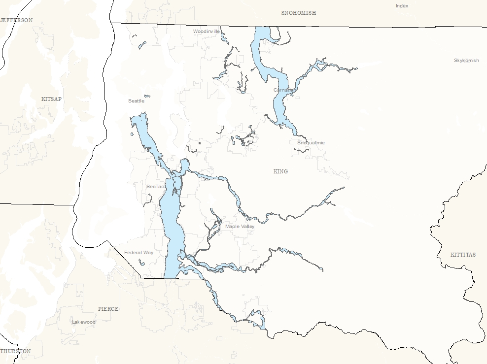
The purpose of this area is to show the inundation areas of dams within King County that have preidentified inundation maps.
Description
The inundated areas shown on this map reflect events of an unlikely possibility and are not in any way intended to reflect upon the integrity of any of the dams within King County.
Because of the methods, procedures, and assumptions used to develop the flooded area, and the inherit uncertainty of dam break simulations, the limits of flooding and data values shown are approximate and should be used only as a guideline.
Actual areas inundated will depend on failure conditions and may differ from mapping shown.
No warranties of any sort, including accuracy, fitness or merchantability, accompany this product.
Layer information
| Layer Name | dam_inundation_area |
| Subject Category | Public Safety |
| Title | Dam Inundation Areas |
| Feature Count | 40 |
| Feature Type | Polygon |
| Spatial reference | EPSG:2926 |
| Control ID | 2867 |
| Place Keywords | Washington State, King County, WA, Pacific NW |
| Theme Keywords | Pubsafe, Public Safety |
| Supplemental Information | None |
Attribute information
|
OBJECTID
From Esri |
Description
Internal feature number. DomainSequential unique whole numbers that are automatically generated. |
|
SHAPE_Leng
From King County |
Description
Not Found Domain0.0, 0.01563506, 0.01822617, 0.02104034, 0.0251793, 0.02575955, 0.02808673, 0.03267712, 0.03615496, 0.04081046, 0.0430628, 0.04935846, 0.05080757, 0.05130807, 0.0544982, 0.05489962, 0.06215029, 0.06286371, 0.06471973, 0.07879437, 0.08194864, 0.08452119, 0.08525288, 0.09685993, 0.09950453, 0.1099695, 0.11001969, 0.11098619, 0.11166949, 0.11804741, 0.14032089, 0.14110265, 0.15246126, 0.15640058, 0.31558379, 1.28750375, 2.72563688, 2.95314331, 27156.6675733 |
|
INUNDATION_AREA
From King County |
Description
Not Found Domain0.0, 2210506496.0 |
|
PERIMETER
From King County |
Description
Not Found Domain0.0, 1016982.25 |
|
DAM_NAME
From King County |
Description
Not Found DomainBitter Lake Reservoir, Boeing Creek Dam, Cedar Falls Masonry Dam, Crystal Lake Dam, Culmback Dam, Des Moines Creek Berm, Garrison Creek Stormwater Dam, High Point Redev. Strmwtr. Dam, Howard A Hanson Dam, Icon Materials Sediment Pond 6, Issaquah Highlands NP2 Dam, Issaquah Highlands NPE Pond, Issaquah Highlands Reid Pond, Issaquah Highlands South Pond, Issaquah Highlands WSDOT Pond, Johnson Pond Dam, Kayak Lake Dam, Lake Margaret Dam, Lakemont Stormwater Pond, Madsen Creek W Basin Dam, Marcel Lake Dam, Mud Mountain Dam, Newcastle RR Embankment Dam, Newcastle Vista Dvlpmnt Pond 3, Panther Lake Detention Dam, Peterson Pond, Redmond Ridge Cedar Dam, Redmond Ridge Detention Pond, Redmond Ridge E Pond SRS1 No.1, Redmond Ridge Roadway Dam, Snoq.Ridge Douglas Ave. D1 Dam, South Fork Tolt River Dam, South Ridge Stormwater Dam, SW Genesee St Detention Dam, Talus P5 Stormwater Dam, Trossachs Detention Pond PC-2, Volunteer Park Reservoir, Welcome Lake Dam, Yellow Lake Outlet Dike, Young Lake Outlet Dam |
|
SCENARIO
From King County |
Description
Not Found DomainNot Found |
|
Shape
From Esri |
Description
Feature geometry. DomainCoordinates defining the features. |
|
Shape.STArea()
From SQL Server |
Description
Returns the area of a geometry instance in square units, based on the spatial reference identifier (SRID) of the geometry. DomainDouble |
|
Shape.STLength()
From SQL Server |
Description
Returns the total length of the elements in a geometry instance. DomainDouble |
Contact information
| Maintained by | DES - Emergency Management 911 Program Office |
| Primary |
Jared Schneider
jaschneider@kingcounty.gov |
Terms of Use
| License | Terms of use and copyright |
Use this Data
|
Links
How to use in ArcGIS Pro |
|
| Sharing Status | Not Public |
Summary
The purpose of this area is to show the inundation areas of dams within King County that have preidentified inundation maps.
Description
The inundated areas shown on this map reflect events of an unlikely possibility and are not in any way intended to reflect upon the integrity of any of the dams within King County.
Because of the methods, procedures, and assumptions used to develop the flooded area, and the inherit uncertainty of dam break simulations, the limits of flooding and data values shown are approximate and should be used only as a guideline.
Actual areas inundated will depend on failure conditions and may differ from mapping shown.
No warranties of any sort, including accuracy, fitness or merchantability, accompany this product.
Contact information
| Maintained by | DES - Emergency Management 911 Program Office |
| Primary |
Jared Schneider
jaschneider@kingcounty.gov |
Terms of use and copyright
| License | Terms of use and copyright |