
GIS Data Catalog
Growth Patterns in King County
Learn how to get an ArcGIS Online account 🗺
Use this Data
|
Links
How to use in ArcGIS Pro |
|
| Sharing Status | Not Public |
Summary
This was created as a generalization of planned land use to be included in the first chapter of the county's comprehensive plan prior to 2000.
The layer no longer has an official purpose, as far as the comprehensive plan goes.
But it is still used in the iMap Property Information map set.
It is a great way to generalize the land use of the county for map display at small scales (suitable for mapping at 1:500,000).
Description
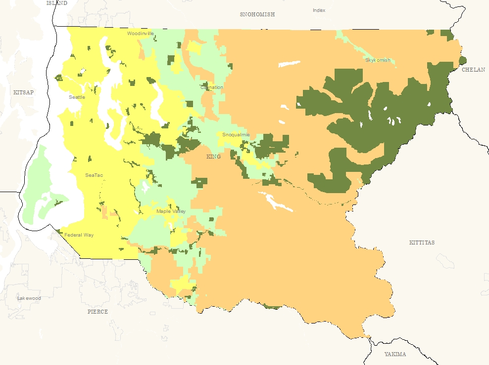
A generalized land use layer.
There are four categories defined in grwthpat.
Urban - those lands within the urban growth boundary that are not open space.
Rural - those areas outside the urban growth boundary that are not resource lands or open space.
Resource - those lands that are within the agricultural and forest production districts that are not open space.
Open - Parks and other publicly owned lands that are set aside as open space.
The data were created by using the UGA, FPD, and APD to define the first three categories, then the open space was overlaid using the parks layer.
There was some generalization of the open space in order to keep the map simple (that is small pockets of open space may have been dropped out).
Parcel boundaries are used to create this layer.
Layer information
| Layer Name | growth_pattern_area |
| Subject Category | Planning |
| Title | Growth Patterns in King County |
| Feature Count | 1405 |
| Feature Type | Polygon |
| Next Update | None planned |
| Spatial reference | EPSG:2926 |
| Control ID | 432 |
| Place Keywords | Washington State, King County, WA, Pacific NW |
| Theme Keywords | Urban Growth, Land Use, Planning, Planningcadastre |
| Supplemental Information |
None |
Attribute information
|
Shape
From ESRI |
Description
Feature Geometry DomainCoordinates defining the features |
|
PATTERN
From Derived from FPD, APD, UGA, Park layers |
Description
Contains values that determine the generalized land use categories Domain(no value) Open - Parks and other publicly owned lands that are set aside as open space Resource - those lands that are within the agricultural and forest production districts that are not open space. Rural - Those areas outside the urban growth boundary that are not resource lands or open space. Urban - Those lands within the urban growth boundary that are not open space. Rural - those areas outside the urban growth boundary that are not resource lands or open space. |
|
OBJECTID
From ESRI |
Description
Internal feature number. DomainSequential unique whole numbers that are automatically generated. |
|
Shape.STArea()
From SQL Server |
Description
Returns the area of a geometry instance in square units, based on the spatial reference identifier (SRID) of the geometry. DomainDouble |
|
Shape.STLength()
From SQL Server |
Description
Returns the total length of the elements in a geometry instance. DomainDouble |
Contact information
| Maintained by | DLS - Permitting |
| Primary |
Paul McCombs
paul.mccombs@kingcounty.gov |
Terms of Use
| License | Terms of use and copyright |
Use this Data
|
Links
How to use in ArcGIS Pro |
|
| Sharing Status | Not Public |
Summary
This was created as a generalization of planned land use to be included in the first chapter of the county's comprehensive plan prior to 2000.
The layer no longer has an official purpose, as far as the comprehensive plan goes.
But it is still used in the iMap Property Information map set.
It is a great way to generalize the land use of the county for map display at small scales (suitable for mapping at 1:500,000).
Description
A generalized land use layer.
There are four categories defined in grwthpat.
Urban - those lands within the urban growth boundary that are not open space.
Rural - those areas outside the urban growth boundary that are not resource lands or open space.
Resource - those lands that are within the agricultural and forest production districts that are not open space.
Open - Parks and other publicly owned lands that are set aside as open space.
The data were created by using the UGA, FPD, and APD to define the first three categories, then the open space was overlaid using the parks layer.
There was some generalization of the open space in order to keep the map simple (that is small pockets of open space may have been dropped out).
Parcel boundaries are used to create this layer.
Contact information
| Maintained by | DLS - Permitting |
| Primary |
Paul McCombs
paul.mccombs@kingcounty.gov |
Terms of use and copyright
| License | Terms of use and copyright |
Change history
| 6/12/2025 |
Changed shape field type to MS SQL Server Native geometry. |
| 1/4/2019 |
*** Erased the Major Water Bodies Lakes |
| Update 3 |
rename grwthpat_area to growth_pattern_area. migrate with steward tool for downtown. |
| Update 4 |
The data were created by using the UGA, FPD, and APD layers to define the Urban, Rural and Resource categories, then the open space was overlaid using the parks layer. There was some generalization of the open space in order to keep the map simple (that is, small pockets of open space may have been dropped out). The layer is not intended to be used at a large scale. It it suitable for mapping at 1:500,000. |