
GIS Data Catalog
KCACODE
Learn how to get an ArcGIS Online account 🗺
Use this Data
|
Links
How to use in ArcGIS Pro |
|
| Sharing Status | Not Public |
Summary
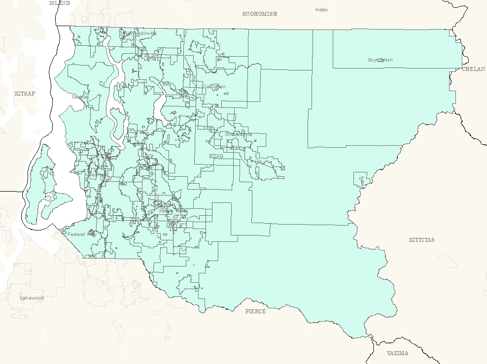
The levy code layer is used to help visualize the complex intersection of various taxing district boundaries throughout King County for the current certified tax roll year.
The data reflects the levy code boundary as described for the purpose of levying taxes.
It does not represent the legal boundary of each
Description
King County has over 100 individual taxing districts.
The overlapping districts combine to make over 550 unique tax levy areas.The levy code describes the unique combination of taxing districts that make up a specific area.
The data reflects the combination of the district boundaries as described for the purpose of levying taxes.
The data identifies the levy code as well as the breakdown of the districts within the levy code.
The data reflects the levy code boundary as described for the purpose of levying taxes.
It does not represent the legal boundary of each The data is updated annually and represents the most recent certified tax roll.
Layer information
| Layer Name | kcacode_area |
| Subject Category | Property |
| Title | KCACODE |
| Feature Count | 486 |
| Feature Type | Polygon |
| Next Update | Annually |
| Spatial reference | EPSG:2926 |
| Control ID | 331 |
| Place Keywords | Washington State, King County, WA, Pacific NW |
| Theme Keywords | None, Property |
| Supplemental Information |
None |
Attribute information
|
OBJECTID
From ESRI |
Description
Internal feature number. DomainSequential unique whole numbers that are automatically generated. |
|
Shape
From ESRI |
Description
Feature Geometry DomainCoordinates defining the features |
|
CITYRD
No Source Noted |
Description
Not Found DomainNot Found |
|
LEVYCODE
No Source Noted |
Description
Not Found DomainNot Found |
|
WAT
No Source Noted |
Description
Not Found DomainNot Found |
|
SCH
No Source Noted |
Description
Not Found Domain0 to 888 by 1 |
|
FIRE
No Source Noted |
Description
Not Found Domain(no value), 2, 4, 10, 10-1, 11, 13, 14, 16, 16-7, 16-8, 17, 17-2, 20, 24, 25, 26, 27, 27-1, 28, 31, 34, 34-1, 36, 36-1, 37, 37-7, 38, 39, 40, 41, 43, 44, 44-1, 45, 47, 49, 50 |
|
RST
No Source Noted |
Description
Not Found DomainNot Found |
|
SEW
No Source Noted |
Description
Not Found Domain(no value), BMLR, HS, LHUD, MID, NELW, NESS, SCWS, SNPS, SPS, SWMD, SWS, VI, VV, WWSD |
|
HOSP
No Source Noted |
Description
Not Found Domain(no value), H-1, H-2, H-4, H-4-1 |
|
LIB
No Source Noted |
Description
Not Found Domain(no value), LIB, LIB-1, LIB-5 |
|
OTH1
No Source Noted |
Description
Not Found Domain(no value), CPR, EPR, FHPR, ISLB, NPR, PCLS, SPR, SVPD, VPR |
|
OTH2
No Source Noted |
Description
Not Found Domain(no value), CAP |
|
OTH4
No Source Noted |
Description
Not Found DomainNot Found |
|
OTH3
No Source Noted |
Description
Not Found Domain(no value), C-1, ISLB, RMLB |
|
SHAPE_STArea__
No Source Noted |
Description
Not Found DomainNot Found |
|
SHAPE_STLength__
No Source Noted |
Description
Not Found DomainNot Found |
|
NOTES
No Source Noted |
Description
Not Found Domain(no value), 35-22-05 TL 121, EXEMPT, NO X-REF, NOX-REFROWONLY, OP PROP ONLY |
|
Shape.STArea()
From SQL Server |
Description
Returns the area of a geometry instance in square units, based on the spatial reference identifier (SRID) of the geometry. DomainDouble |
|
Shape.STLength()
From SQL Server |
Description
Returns the total length of the elements in a geometry instance. DomainDouble |
Contact information
| Maintained by | Department of Assessments |
| Primary |
Christie Most
christie.most@kingcounty.gov |
Terms of Use
| License | Terms of use and copyright |
Use this Data
|
Links
How to use in ArcGIS Pro |
|
| Sharing Status | Not Public |
Summary
The levy code layer is used to help visualize the complex intersection of various taxing district boundaries throughout King County for the current certified tax roll year.
The data reflects the levy code boundary as described for the purpose of levying taxes.
It does not represent the legal boundary of each
Description
King County has over 100 individual taxing districts.
The overlapping districts combine to make over 550 unique tax levy areas.The levy code describes the unique combination of taxing districts that make up a specific area.
The data reflects the combination of the district boundaries as described for the purpose of levying taxes.
The data identifies the levy code as well as the breakdown of the districts within the levy code.
The data reflects the levy code boundary as described for the purpose of levying taxes.
It does not represent the legal boundary of each The data is updated annually and represents the most recent certified tax roll.
Contact information
| Maintained by | Department of Assessments |
| Primary |
Christie Most
christie.most@kingcounty.gov |
Terms of use and copyright
| License | Terms of use and copyright |
Change history
| 1/1/2002 |
The Assessor Levy Code maps were converted to GIS data during 2002. Boundaries for the levy data are updated as necessary throughout the year. |