
GIS Data Catalog
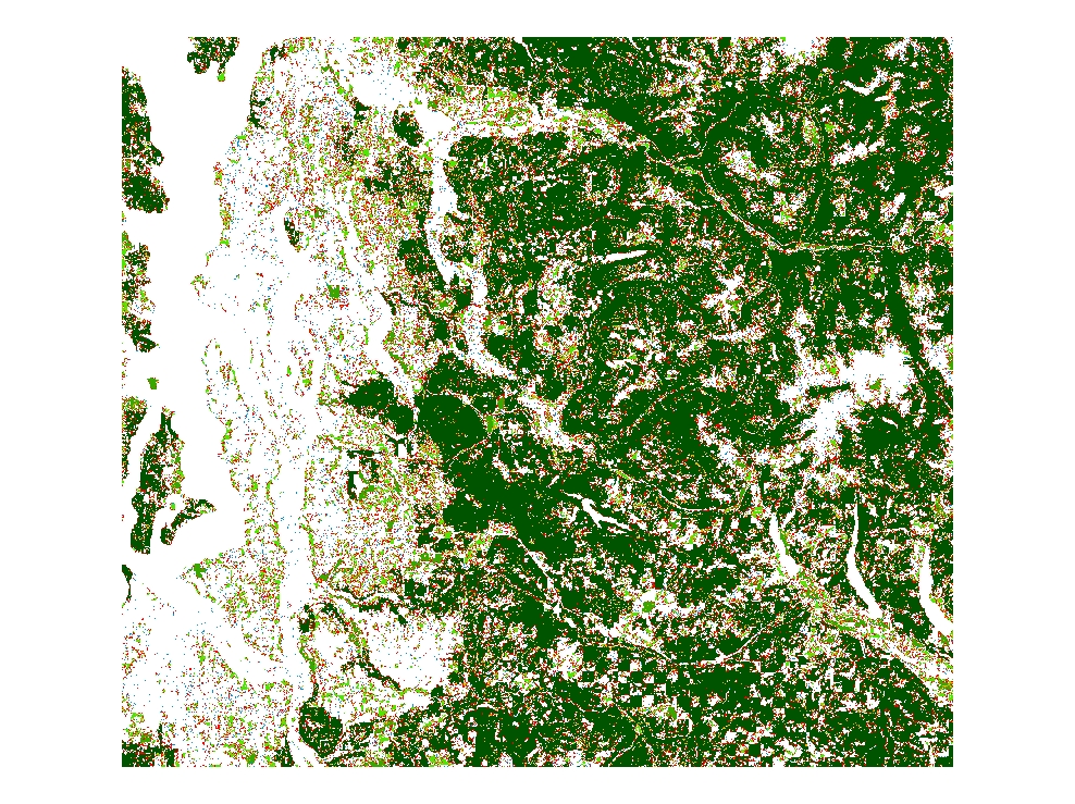
1996 C-CAP Forest Fragmentation Data for King County for Years 1992, 1996, 2001 and 2006
Learn more by reading the GIS FAQ 🗺
Summary
To develop an understanding of the effects that forest fragmentation has on coastal uplands and wetlands.
Description
The Coastal Change Analysis Program (C-CAP) produces a nationally standardized database of land cover and land change information for the coastal regions of the U.S. () C-CAP products provide inventories of coastal intertidal areas, wetlands, and adjacent uplands with the goal of monitoring these habitats by updating the land cover maps every five years.
C-CAP data can be used as a base layer for many GIS applications, or as an input for tools that produced derived products such as impervious layers or land fragmentation layers.
Forest fragmentation, as defined by the Society of American Foresters, is the process of dividing large tracts of forest into smaller isolated tracts surrounded by human modified environments.
Increased fragmentation negatively impacts a forest ecosystem's ability to protect water flow and quality, provide healthy habitat, and can impact its value as a timber and recreational resource.
The forest fragmentation data is a value added, post-processed product that has been derived from NOAA Coastal Services Center C-CAP land cover products
Layer information
| Layer Name | LANDCOVER_CCAPForestFragmentation1996 |
| Subject Category | Imagery |
| Title | 1996 C-CAP Forest Fragmentation Data for King County for Years 1992, 1996, 2001 and 2006 |
| Feature Count | 1 |
| Feature Type | Raster |
| Spatial reference | None |
| Control ID | None |
| Place Keywords | Washington, Coastal Zone, US West Coast |
| Theme Keywords | Remotely Sensed Imagery/Photos, Forest Fragmentation, Land Cover Analysis |
| Supplemental Information | None |
Attribute information
|
OBJECTID
From Esri |
Description
Internal feature number. DomainSequential unique whole numbers that are automatically generated. |
|
Shape
From Esri |
Description
Feature geometry. DomainCoordinates defining the features. |
|
MosaicID
No Source Noted |
Description
Not Found DomainNot Found |
|
SHAPE_Length
From Esri |
Description
Length of feature in internal units. DomainPositive real numbers that are automatically generated. |
|
SHAPE_Area
From Esri |
Description
Area of feature in internal units squared. DomainPositive real numbers that are automatically generated. |
Contact information
| Maintained by | KCGIS Center |
| Primary |
KCGIS Center
giscenter@kingcounty.gov |
Terms of Use
| License | Terms of use and copyright |
Summary
To develop an understanding of the effects that forest fragmentation has on coastal uplands and wetlands.
Description
The Coastal Change Analysis Program (C-CAP) produces a nationally standardized database of land cover and land change information for the coastal regions of the U.S. () C-CAP products provide inventories of coastal intertidal areas, wetlands, and adjacent uplands with the goal of monitoring these habitats by updating the land cover maps every five years.
C-CAP data can be used as a base layer for many GIS applications, or as an input for tools that produced derived products such as impervious layers or land fragmentation layers.
Forest fragmentation, as defined by the Society of American Foresters, is the process of dividing large tracts of forest into smaller isolated tracts surrounded by human modified environments.
Increased fragmentation negatively impacts a forest ecosystem's ability to protect water flow and quality, provide healthy habitat, and can impact its value as a timber and recreational resource.
The forest fragmentation data is a value added, post-processed product that has been derived from NOAA Coastal Services Center C-CAP land cover products
Contact information
| Maintained by | KCGIS Center |
| Primary |
KCGIS Center
giscenter@kingcounty.gov |
Terms of use and copyright
| License | Terms of use and copyright |
Change history
| Update 1 |
CSC used the Landscape Fragmentation Tool (LFT) v. 2.0 from the University of Connecticut CLEAR website (clear.uconn.edu/tools/lft/lft2/index.htm). Each date of the CCAP images for each coastal state were recoded from 25 classes to 3 classes. The deciduous forest, mixed forest, evergreen forest, and palustrine forest classes were recoded to Forest (Class 2). All of the remaining classes were recoded to Non-Forest (Class 1). Class 0 is the background class. The recoded 3 class images were input into the fragmentation tool. An edge width of 30 meters was used in the fragmentation tool analysis. The fragmentation tool outputs 6 classes, which include patch forest (Class 1), perforated forest (Class 2), edge forest (Class 3), core forest <250 acres (Class 4), core forest 250-500 acres (Class 5), core forest >500 acres (Class 6). Attributes for this product are as follows: 0 Background 1 Patch Forest 2 Perforated Forest 3 Edge Forest 4 Core Forest < 250 acres 5 Core Forest >250 acres and <500 acres 6 Core Forest >500 acres. |