
GIS Data Catalog
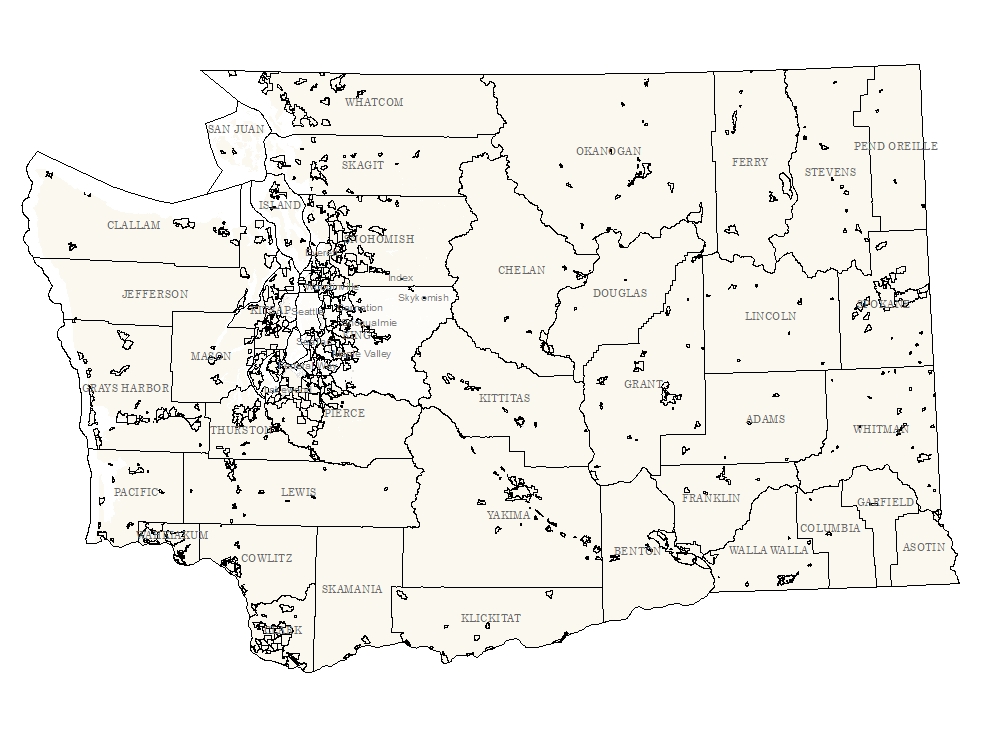
2010 Census Places for Washington - Not conflated to KC Base Data
Learn how to get an ArcGIS Online account 🗺
Use this Data
|
Links
How to use in ArcGIS Pro |
|
| Sharing Status | Not Public |
Summary
In order for others to use the information in the Census MAF/TIGER database in a geographic information system (GIS) or for other geographic applications, the Census Bureau releases to the public extracts of the database in the form of TIGER/Line Shapefiles.
Description
The TIGER/Line Files are shapefiles and related database files (.dbf) that are an extract of selected geographic and cartographic information from the U.S. Census Bureau's Master Address File / Topologically Integrated Geographic Encoding and Referencing (MAF/TIGER) Database (MTDB).
The MTDB represents a seamless national file with no overlaps or gaps between parts, however, each TIGER/Line File is designed to stand alone as an independent data set, or they can be combined to cover the entire nation.
The TIGER/Line Files include both incorporated places (legal entities) and census designated places or CDPs (statistical entities).
An incorporated place is established to provide governmental functions for a concentration of people as opposed to a minor civil division (MCD), which generally is created to provide services or administer an area without regard, necessarily, to population.
Places always nest within a State, but may extend across county and county subdivision boundaries.
An incorporated place usually is a city, town, village, or borough, but can have other legal descriptions.
CDPs are delineated for the decennial census as the statistical counterparts of incorporated places.
CDPs are delineated to provide data for settled concentrations of population that are identifiable by name, but are not legally incorporated under the laws of the State in which they are located.
The boundaries for CDPs often are defined in partnership with State, local, and/or tribal officials and usually coincide with visible features or the boundary of an adjacent incorporated place or another legal entity.
CDP boundaries often change from one decennial census to the next with changes in the settlement pattern and development; a CDP with the same name as in an earlier census does not necessarily have the same boundary.
The only population/housing size requirement for CDPs for the 2010 Census is that they must contain some housing and population.
The boundaries of all 2010 Census incorporated places are as of January 1, 2010 as reported through the Census Bureau's Boundary and Annexation Survey (BAS).
The boundaries of all 2010 Census CDPs were delineated as part of the Census Bureau's Participant Statistical Areas Program (PSAP).
Layer information
| Layer Name | place10_area |
| Subject Category | Census |
| Title | 2010 Census Places for Washington - Not conflated to KC Base Data |
| Feature Count | 628 |
| Feature Type | Polygon |
| Next Update | None planned |
| Spatial reference | EPSG:2926 |
| Control ID | 861 |
| Place Keywords | Pacific NW, Washington State, King County, WA |
| Theme Keywords | Census Designated Place, Demographic, Census, Village, Town, CDP, City |
| Supplemental Information |
TIGER/Line Shapefiles are extracted from the Census MAF/TIGER database. No changes or updates will be made to this version of the TIGER/Line Shapefiles. Future releases of TIGER/Line Shapefiles will reflect updates made to the Census MAF/TIGER database. |
Attribute information
|
OBJECTID
From ESRI |
Description
Internal feature number. DomainSequential unique whole numbers that are automatically generated. |
|
SHAPE
From ESRI |
Description
Feature Geometry DomainCoordinates defining the features |
|
STATEFP10
From U.S. Census Bureau |
Description
2010 Census state Federal Information Processing Standards Domain53 - Washington |
|
PLACEFP10
From U.S. Census Bureau |
Description
2010 Census place Federal Information Processing Standards DomainFederal Information Processing Series Census Codes for Named Populated Places, Primary County Divisions, and other Locational Entities of the United States, Puerto Rico, and the Island Areas (Formerly FIPS 55-3) |
|
PLACENS10
From U.S. Census Bureau |
Description
2010 Census place ANSI code DomainINCITS 446-2008, (GNIS) Identifying Attributes for Named Physical and Cultural Geographic Features (Except Roads and Highways) of the United States, Its Territories, Outlying Areas, and Freely Associated Areas, and the Waters of the Same to the Limit of the Twelve-Mile Statutory Zone |
|
GEOID10
From U.S. Census Bureau |
Description
Place identifier; a concatenation of 2010 Census state FIPS DomainINCITS.38-200x (R2004), Codes for the Identification of the States, the District of Columbia, Puerto Rico, and the Insular Areas of the United States (Formerly FIPS 5-2), Federal Information Processing Series Census Codes for Named Populated Places, Primary County Divisions, and other Locational Entities of the United States, Puerto Rico, and the Island Areas (Formerly FIPS 55-3) |
|
NAME10
From U.S. Census Bureau |
Description
2010 Census place name DomainRefer to the place Gazetteer file at URL: http://www.census.gov/geo/www/gazetteer/gazette.html |
|
NAMELSAD10
From U.S. Census Bureau |
Description
2010 Census name and the translated legal/statistical area DomainRefer to the place Gazetteer file at URL: http://www.census.gov/geo/www/gazetteer/gazette.html and the translated legal/statistical area description code for place that appears in LSAD10 |
|
LSAD10
From U.S. Census Bureau |
Description
2010 Census legal/statistical area description code for place Domain25 - city 43 - town 57 - census designated place (CDP) |
|
CLASSFP10
From U.S. Census Bureau |
Description
2010 Census Federal Information Processing Standards (FIPS) 55 DomainC1 - An active incorporated place that does not serve as a county subdivision M2 - A military or other defense installation entirely within a place U1 - A census designated place with an official federally recognized name U2 - A census designated name without an official federally recognized name |
|
PCICBSA10
From U.S. Census Bureau |
Description
2010 Census metropolitan or micropolitan statistical area DomainN - Not a principal city of a CBSA Y - Is a principal city of a CBSA |
|
PCINECTA10
From U.S. Census Bureau |
Description
2010 Census New England city and town area principal city DomainN - Geographic entity is not a principal city of a NECTA |
|
MTFCC10
From U.S. Census Bureau |
Description
MAF/TIGER feature class code DomainG4110 - Incorporated Place G4210 - Census designated place |
|
FUNCSTAT10
From U.S. Census Bureau |
Description
2010 Census functional status DomainA - Active government providing primary general-purpose functions S - Statistical entity |
|
ALAND10
From U.S. Census Bureau |
Description
2010 Census land area (square meters) Domain148793 to 217410345 by 1 |
|
AWATER10
From U.S. Census Bureau |
Description
2010 Census water area (square meters) Domain0 to 152055857 by 1 |
|
INTPTLAT10
From U.S. Census Bureau |
Description
2010 Census latitude of the internal point DomainLatitude as string with leading positive sign |
|
INTPTLON10
From U.S. Census Bureau |
Description
2010 Census longitude of the internal point DomainLongitude as string with leading negative sign |
|
Shape.STArea()
From SQL Server |
Description
Returns the area of a geometry instance in square units, based on the spatial reference identifier (SRID) of the geometry. DomainDouble |
|
Shape.STLength()
From SQL Server |
Description
Returns the total length of the elements in a geometry instance. DomainDouble |
Contact information
| Maintained by | KCGIS Center |
| Primary |
KCGIS Center
giscenter@kingcounty.gov |
Terms of Use
| License | Terms of use and copyright |
Use this Data
|
Links
How to use in ArcGIS Pro |
|
| Sharing Status | Not Public |
Summary
In order for others to use the information in the Census MAF/TIGER database in a geographic information system (GIS) or for other geographic applications, the Census Bureau releases to the public extracts of the database in the form of TIGER/Line Shapefiles.
Description
The TIGER/Line Files are shapefiles and related database files (.dbf) that are an extract of selected geographic and cartographic information from the U.S. Census Bureau's Master Address File / Topologically Integrated Geographic Encoding and Referencing (MAF/TIGER) Database (MTDB).
The MTDB represents a seamless national file with no overlaps or gaps between parts, however, each TIGER/Line File is designed to stand alone as an independent data set, or they can be combined to cover the entire nation.
The TIGER/Line Files include both incorporated places (legal entities) and census designated places or CDPs (statistical entities).
An incorporated place is established to provide governmental functions for a concentration of people as opposed to a minor civil division (MCD), which generally is created to provide services or administer an area without regard, necessarily, to population.
Places always nest within a State, but may extend across county and county subdivision boundaries.
An incorporated place usually is a city, town, village, or borough, but can have other legal descriptions.
CDPs are delineated for the decennial census as the statistical counterparts of incorporated places.
CDPs are delineated to provide data for settled concentrations of population that are identifiable by name, but are not legally incorporated under the laws of the State in which they are located.
The boundaries for CDPs often are defined in partnership with State, local, and/or tribal officials and usually coincide with visible features or the boundary of an adjacent incorporated place or another legal entity.
CDP boundaries often change from one decennial census to the next with changes in the settlement pattern and development; a CDP with the same name as in an earlier census does not necessarily have the same boundary.
The only population/housing size requirement for CDPs for the 2010 Census is that they must contain some housing and population.
The boundaries of all 2010 Census incorporated places are as of January 1, 2010 as reported through the Census Bureau's Boundary and Annexation Survey (BAS).
The boundaries of all 2010 Census CDPs were delineated as part of the Census Bureau's Participant Statistical Areas Program (PSAP).
Contact information
| Maintained by | KCGIS Center |
| Primary |
KCGIS Center
giscenter@kingcounty.gov |
Terms of use and copyright
| License | Terms of use and copyright |
Change history
| 1/1/2010 |
TIGER/Line Shapefiles are extracted from the Census MAF/TIGER database by nation, state, county, and entity. Census MAF/TIGER data for all of the aforementioned geographic entities are then distributed among the shapefiles each containing attributes for line, polygon, or landmark geographic data. |