
GIS Data Catalog
Wetland class excerpted from WTRBDY
Learn how to get an ArcGIS Online account 🗺
Use this Data
|
Links
How to use in ArcGIS Pro |
|
| Sharing Status | Not Public |
Summary
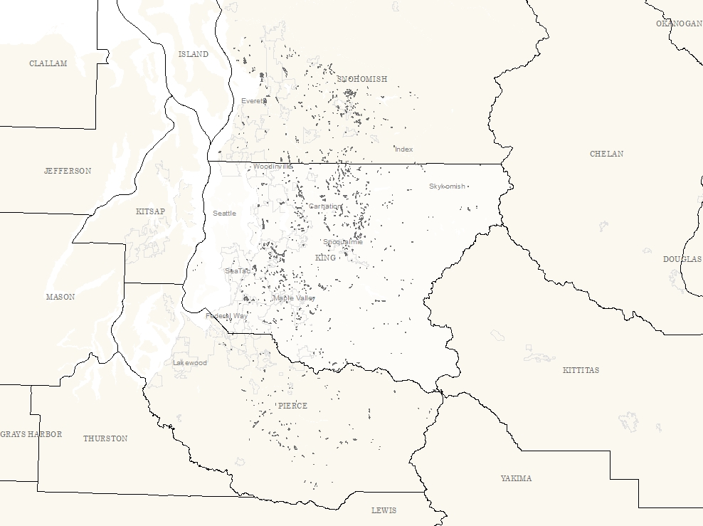
General wetland and wet area boundary and definition descriptions, independent of open water waterbody areas.
Description
Extract of wetland areas (wtr_type_c =111) from WTRBDY.
WTRBDY shows only open water areas and double-banked streams.
Wetland areas are shown in layers WETLD and WTRBDY_WET; reflecting different sources.
Layer information
| Layer Name | wtrbdy_wet_area |
| Subject Category | Hydrography |
| Title | Wetland class excerpted from WTRBDY |
| Feature Count | 1507 |
| Feature Type | Polygon |
| Next Update | As needed |
| Spatial reference | EPSG:2926 |
| Control ID | 141 |
| Place Keywords | Washington State, King County, WA, Pacific NW |
| Theme Keywords | Hydrology, Hydro, None |
| Supplemental Information |
None |
Attribute information
|
OBJECTID
From ESRI |
Description
Internal feature number. DomainSequential unique whole numbers that are automatically generated. |
|
WTR_TYPE_C
No Source Noted |
Description
Not Found Domain111, 421 |
|
WTR_TYPE
No Source Noted |
Description
Not Found Domainwetland |
|
DATA_SRCE
No Source Noted |
Description
Not Found DomainCedar River Topo Survey, Cedar River Topo Survey - 3/00, City of Kent, KC Hydrography Project, MAA APD Mapping Project, Middle Green River Topo Survey, Mill Creek Topo Survey, SF Skykomish River Topo Survey, SF Skykomish Topo Survey, SF Snoqualmie River Topo Survey, Tolt River Topo Survey |
|
WTR_NAME
No Source Noted |
Description
Not Found Domain(no value), Alturas Lake, Fury Lake, Harts Swamp', Hidden Lake, Metcalf Marsh, Moneysmith Lake, Mooney Swamp, Orting Lake, Panther Lake, Platt Pond, Profitts Pond, Roths Swamp, Round Lake, Totem Lake, Tradition Lake |
|
WTR_ACRE
No Source Noted |
Description
Not Found Domain0.004 to 181.065 by |
|
SHAPE
From ESRI |
Description
Feature geometry. DomainCoordinates defining the features. |
|
Shape.STArea()
From SQL Server |
Description
Returns the area of a geometry instance in square units, based on the spatial reference identifier (SRID) of the geometry. DomainDouble |
|
Shape.STLength()
From SQL Server |
Description
Returns the total length of the elements in a geometry instance. DomainDouble |
Contact information
| Maintained by | KCGIS Center |
| Primary |
KCGIS Center
giscenter@kingcounty.gov |
Terms of Use
| License | Terms of use and copyright |
Use this Data
|
Links
How to use in ArcGIS Pro |
|
| Sharing Status | Not Public |
Summary
General wetland and wet area boundary and definition descriptions, independent of open water waterbody areas.
Description
Extract of wetland areas (wtr_type_c =111) from WTRBDY.
WTRBDY shows only open water areas and double-banked streams.
Wetland areas are shown in layers WETLD and WTRBDY_WET; reflecting different sources.
Contact information
| Maintained by | KCGIS Center |
| Primary |
KCGIS Center
giscenter@kingcounty.gov |
Terms of use and copyright
| License | Terms of use and copyright |