
GIS Data Catalog
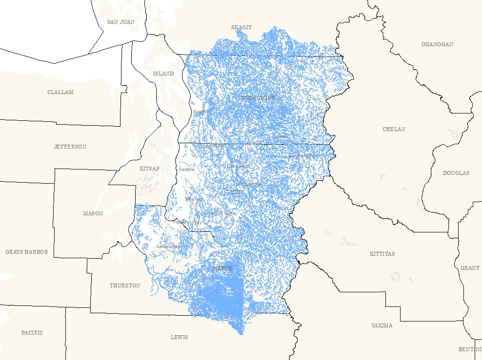
Rivers and Streams for Snohomish, Pierce and King Counties
Learn how to get an ArcGIS Online account 🗺
Use this Data
|
Links
How to use in ArcGIS Pro |
|
| Sharing Status | Not Public |
Summary
Developed to provide a three-county cartographic representation of streams and rivers.
This layer should be used when river and stream information beyond the extent of WTRCRS_LINE is required.
This layer always incorporates the most current state of WTRCRS_LINE (for the King County/SW Snohomish portion), and the best-available data for Pierce and the remainder of Snohomish County.
The only common attribute maintained across all three source datasets is NAME, so this layer does not provide the same level of functionality as found in the original datasets.
Users should refer to the original datasets if requirements for this layer exceed basic cartographic and query functionality.
Description
A three-county (Snohomish, Pierce and King) representation of streams and rivers (as river center lines).
Created by clipping and appending the respective input layers.
Edgematching is not enhanced beyond the default append, but because append edges lie along basin boundaries, so alignment is generally good.
Layer information
| Layer Name | wtrcrs_3co_line |
| Subject Category | Hydrography |
| Title | Rivers and Streams for Snohomish, Pierce and King Counties |
| Feature Count | 62635 |
| Feature Type | Line |
| Next Update | As needed |
| Spatial reference | EPSG:2926 |
| Control ID | 626 |
| Place Keywords | Pacific NW, Snohomish County, Pierce County, King County, WA, Washington State |
| Theme Keywords | Rivers, Watercourses, Hydrology, Inlandwaters, Hydro, Streams |
| Supplemental Information |
The workflow established for this layer requires that WTRCRS_3CO be updated whenever any of the three input layers is modified. For the King County portions, this is anytime the layer is republished to the Spatial Data Warehouse. For the Snohomish and Pierce County data, this is anytime new updates are received from these entities as part of an established data sharing program. This is an approximately semi-annual event. The goal is to maintain WTRCRS_3CO to be as current as possible; but in particular to ensure that the King County portion of WTRCRS_3CO (geometry and NAME item) is fully consistent with the corresponding components of WTRCRS_LINE. |
Attribute information
|
NAME
From County where feature occurs |
Description
Feature name DomainMixed case name (label) of feature; not all features are labeled |
|
OBJECTID
From ESRI |
Description
Internal feature number. DomainSequential unique whole numbers that are automatically generated. |
|
SHAPE
From ESRI |
Description
Feature geometry. DomainCoordinates defining the features. |
|
SHAPE.STLength()
No Source Noted |
Description
Not Found DomainNot Found |
Contact information
| Maintained by | DNRP - Water and Land Resources |
| Primary |
Harkeerat Kang
Harkeerat.Kang@kingcounty.gov |
Terms of Use
| License | Terms of use and copyright |
Use this Data
|
Links
How to use in ArcGIS Pro |
|
| Sharing Status | Not Public |
Summary
Developed to provide a three-county cartographic representation of streams and rivers.
This layer should be used when river and stream information beyond the extent of WTRCRS_LINE is required.
This layer always incorporates the most current state of WTRCRS_LINE (for the King County/SW Snohomish portion), and the best-available data for Pierce and the remainder of Snohomish County.
The only common attribute maintained across all three source datasets is NAME, so this layer does not provide the same level of functionality as found in the original datasets.
Users should refer to the original datasets if requirements for this layer exceed basic cartographic and query functionality.
Description
A three-county (Snohomish, Pierce and King) representation of streams and rivers (as river center lines).
Created by clipping and appending the respective input layers.
Edgematching is not enhanced beyond the default append, but because append edges lie along basin boundaries, so alignment is generally good.
Contact information
| Maintained by | DNRP - Water and Land Resources |
| Primary |
Harkeerat Kang
Harkeerat.Kang@kingcounty.gov |
Terms of use and copyright
| License | Terms of use and copyright |
Change history
| 6/1/2009 |
UPDATED FROM BASE DATA Updated from WTRCRS_LINE (200904), F61_WTRCRS (200904) and F53_HYDRO (200905) |
| 3/1/2009 |
UPDATE DUE TO REPUBLISHED WTRCRS_LINE WTRCRS_LINE was rebuilt to support linear measure as a routed system. This entailed additional geometry edits as well as changes to the schema. However, the only schema item used in WTRCRS_3CO is NAME which was unaffected. This update also allowed the most current Snohomish and Pierce County data to be incorporated. |
| Update 3 |
PERFORM TABLE MANAGEMENT: Though all three source datasets contain multiple user attributes, only the feature name can be extracted from all three consistently. All other attributes from the source layers are dropped, and the NAME item is populated with the appropriate information from all three layers. Case-sensitivity (mixed case) is standardized. |
| Update 4 |
CLIP DATA TO EXTENTS: Even though the King County WTRCRS_LINE input layer has an extent consistent to the clip boundary, the input layer is clipped to ensure that there will be no overlapping geometry with the Snohomish and Pierce County data. The same clip boundary polygon is then used to erase data from the other two county datasets so that all features merge along the clip/erase boundary. |
| Update 5 |
APPEND INPUTS TO SINGLE LAYER: After the geometry and attribute schema of all three input layers has been modified, the three pieces are appended to a target template and output as a single featureclass. |
| Update 6 |
ASSEMBLE SOURCE DATA: The three source data sets are assembled. Pierce and Snhomish data are imported to Feature classes from their shapefile source. The King County portion is copied from its current version from the Spatial Data Warehouse. |